 Port Credit Marine Survey & Yacht Delivery |
11. Navigation Equipment |
Port Credit Marine Survey & Yacht Delivery |
11. Navigation Equipment |
| Chartplotters -A few years back I was delivering a million
dollar boat out of a harbour on Georgian Bay. I stayed up the night before and programmed
the three just installed, state of
the art
chart plotters. I was reasonably familiar
with the waters and knew that I would
pass
rocks awash to starboard and a little
later
change course. We passed the rocks
and I
complacently waited for the plotter
to tell
me I had reached my course change waypoint.
When I saw a second shoal I knew something
was wrong and stopped the boat. While
surrounded
by rock shoals and frantically trying
to
find out where I was, I noticed that
the
plotter screen had frozen 10 minutes
before.
I went back to my compass, dividers
and parallel rule. Over the course of the next 12 hours the other two plotters froze without warning but that was OK because I was no longer navigating by them. Chart plotters are no more than computers. How many times have you tried something on your PC that you have doing for years and it no longer works ? How many times has your laptop frozen? How many times has your PC crashed or simply turned itself off and refused to restart ? .......... So why would you trust your life to a chartplotter that is just another computer ? To be fair they are an excellent aid to navigation but just that …. an aid. The problem is that like me, too many people get complacent with them and start to believe what they see on the screen. They follow that skinny magenta course line on the fancy colour screen and forget to look out the window. Complicating matters is the fact that hundreds of marks at river mouths and sounds are moved frequently and many are not charted because they move so often. |
|
 |
 |
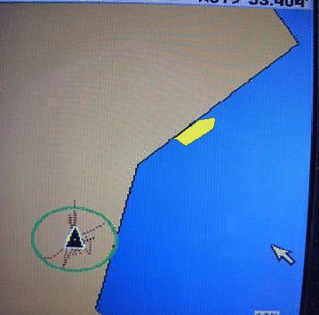
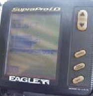
| The black triangle is the chartplotter boat, I drew in the yellow boat in the actual position about 250’ from the plotter position. The boat was tied to a wall and the plotter left on for an hour. The black lines around the plotter boat are the tracks of the GPS wandering around. This is a DGPS/WAAS plotter…. Still want to navigate narrow channels in the fog with these things ? | This plotter could not be trusted in a narrow channel in the Trent Waterway. I swear I didn't take the boat up there. |
|
Want some more complications ?…. Other than major commercial routes, many charts (not only electronic) are based on surveys done in the 1950’s and in the Caribbean some charts still rely on the work of Lord Nelson. Now to contradict everything said so far
….. As accurate as GPS is in relationship to
the model grid, the flaw lies in the
relationship
of the grid to the real world. Our
real world
was charted decades ago without the
accuracy
allowed by modern methods. News flash
… the
world is not round, it is a spheroid
(sort
of round but with big lumps) and while
the
model tries to match the shape with
billions
of calculations, it simply can’t with
current
technology and even if it could the
entire
planet would have to be re-surveyed
to match.
This is unlikely to happen in our lifetimes.
|
|
| The following is reprinted from the newsletter
of Peter F. Prowant |
|
Complete reliance on GPS in lieu of other navigation methods is a mistake. The inherent, commonly misunderstood, belief is that GPS receivers capable of accuracy within several meters, place the mariner exactly on the plotted position of the chart or at the exact position of the electronic chart loaded into the chartplotter or navigation computer. The accuracy of a position plotted directly from GPS is, however, limited to the accuracy of the chart. A good example of this is the recent observation by two Bluewater customers within a week, both using electronic chartplotters, that the GPS was not accurate in the vicinity of the island of Bimini, on the western side of the Bahaman Islands. Interestingly, the customers were using chartplotters and digitized cartography from different manufacturers. Yet the complaint and the position errors provided by the chartplotters were exactly the same, placing the vessels approximately 200 yards on the island itself, while navigating into the harbor. How can this be? Simply, the position of Bimini on National Imagery and Mapping Agency Charts and British Admiralty Charts is based on a chart first published in 1844, when surveyed positions were based entirely on celestial observations, hence the apparent error. It is rather amazing to me, that charted positions based on such observations are so accurate! Logically, the question arises, why not just correct the position of Bimini? Unfortunately, correcting charted positions is not that simple, for to move the position of Bimini on the chart would mean that all charted positions of other islands, shoals, coral heads, entrances, lights and so forth on the chart would also have to be corrected relative to each other. |
| Radar -This topic could very easily be a very long
book on its own so I won’t get into
the minutiae.
Note that the Georgian Maritime College radar course is 11 weeks with a very sophisticated simulator, which should give you some idea of what’s involved. Let’s stick to a few highlights. In clear weather and calm seas radar will help find marks you cannot see in the glare. It will detect thunder storms and see floating logs. Of course this presumes that it is properly adjusted which is no simple matter. Properly setting up and adjusting radar cannot be learned from the manual. It is a complex piece of equipment and your fair weather or dockside setup will be virtually worthless when the weather turns. When purchasing a new radar there are a few things to insist on. There is simply no substitute for power, a 5kw radar will pick up things a 2kw unit won’t see except in perfect conditions. Most will pick up seagulls on a calm day but throw in a little rain or wave action and a more powerful unit becomes a very valuable asset especially in places like Manhattan. There are certain functions you will be adjusting constantly and these should not be buried in a digital menu but be up front controls and include range, FTC, STC and gain. Even radar can be confused by the sometimes massive RF (radio frequency) interference around US military bases like those in Norlfolk, Virginia, the mouth of the St.Johns River in Florida or the USCG base in Key West. We have often found our radar screen one solid colour in these areas and even had our depth sounders and GPS display nonsense. |
|
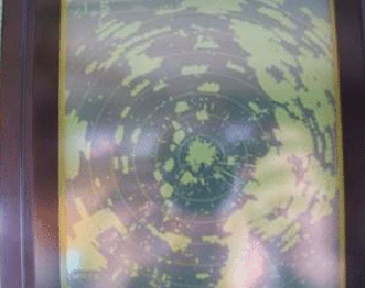
 Our radar screen in Hampton Roads, Norfolk, VA Massive RF interference at this and other military installations can render all of your electronics useless. |
 Rush hour in the harbour at Manhattan is to be avoided. Try transitting early Saturday or Sunday mornings. |
Radar Reflector -I am constantly amazed by the large number of seasoned cruisers who don’t know that if they are less than 20 meters or made of nonmetallic materials are required by Collision Regulations to carry a radar reflector. Those apartment building size ships coming up the Delaware, Chesapeake or running the gulf stream are often running at 20kots plus. I don’t know about you but I want them to see me. If you are one of the few who really know how to use radar you will know that although they are essential there are some things they will not see. We often see large cruisers show up very well abeam or from their stern then disappear from the screen when they turn bow on. FRP absorbs radar rays and sharply angled surfaces can send the beams into space rather than return them to the receiver. I want the big ships and everyone else to see me coming. |
|
|
Depth sounders -Why people will pay upwards of $200 for a
depth sounder is beyond me when a $90
fish
finder will not only show you what
the bottom
looks like but will also point out
dinner.
With a little experience and an observant
nature you will be able to determine
the
structure of the bottom from sand waves,
silt over clay, sand over rock to weed
etc.
|
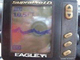 |
Photo at left - Sand waves like these
suggest
opposing currents and good anchoring. Photo at right - That square block is heavily aerated water caused by a passing gofast. The screen will be blank within seconds and may stay that way for up to a minute, too long in a narrow channel. |
 |
| Clearview -A Clearview windshield is so much superior
to wiper blades they shouldn’t even
be mentioned
in the same breath. This glass disk
spins
at such a high RPM that water simply
vapourizes.
Where wipers quickly become nothing
more
than salt smearers, this stays clear
at all
times. Its even heated so when you
leave
Toronto on October 15 (that’s another thing I won’t be doing again
soon) and get hit by the big freeze in Oswego you
will still be able to see . Compass -This is a no brainer, Why don’t you have a properly swung compass with a corrections card ? (and a backup). Binoculars - Plural ! You’ll be sorry if you do not have two pair (good ones). It can be frustrating when you need the binoculars and they are not where you left them. |
 |
Chapter 12. Maps, Charts & Guides. Back to Index Need a marine surveyor in Ontario... See this list of Every Marine Surveyor in Ontario  |
|